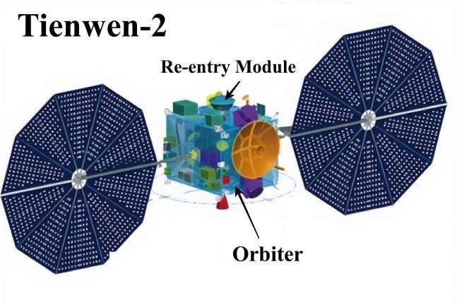
China’s Tianwen 2 asteroid-sampling probe has sent back stunning images of Earth and the moon, showcasing the mission’s progress as it journeys through deep space. Launched to collect samples from a near-Earth asteroid, the spacecraft’s latest photographs and video provide a captivating glimpse of our planet and its natural satellite from a distant vantage point. These breathtaking visuals not only highlight the probe’s advanced imaging capabilities but also mark a significant milestone in China’s expanding ambitions in asteroid exploration and planetary science.
Tianwen 2 Captures Stunning Earth and Moon Imagery During Asteroid Sampling Mission
China’s Tianwen 2 probe has delivered breathtaking visuals of our planet and its natural satellite while hurtling through space on a groundbreaking asteroid sampling mission. Equipped with cutting-edge cameras, the spacecraft managed to capture high-resolution images and videos showcasing Earth’s vibrant blues and swirling clouds alongside the serene, crater-marked surface of the Moon. These mesmerizing snapshots not only provide a rare perspective of our cosmic neighborhood but also underscore the probe’s advanced imaging capabilities essential for its primary scientific objectives.
Beyond the captivating imagery, Tianwen 2’s successful operation highlights key technical milestones:
- Precise Navigation: Maneuvering through deep space to maintain optimal trajectory for asteroid rendezvous.
- High-Definition Imaging: Utilization of multi-spectral cameras to obtain detailed surface data.
- Real-Time Data Transmission: Swift relaying of visual and scientific data to ground control for analysis.
| Feature | Details |
|---|---|
| Orbit Distance | ~400,000 km (Moon flyby) |
| Camera Resolution | Up to 20 megapixels |
| Sample Target | Asteroid 469219 Kamoʻoalewa |
Analyzing the Significance of High-Resolution Photos for Future Deep Space Exploration
High-resolution photography captured by spacecraft like China’s Tianwen 2 unlocks unprecedented opportunities for deep space exploration. These visually stunning images are not just aesthetic achievements; they provide critical scientific data that enhance our understanding of celestial bodies. Detailed surface features of asteroids, moons, and planets become discernible, aiding in geological analysis, landing site selection, and mission planning. Moreover, such clarity facilitates the identification of mineral compositions and potential resources, which are essential for future manned missions and in-situ resource utilization.
The value of high-resolution imaging extends beyond immediate mission goals. As space agencies worldwide collaborate and share data, these images bolster comparative studies that refine existing models of solar system formation and evolution. Below are some core benefits associated with high-resolution photos from deep space probes like Tianwen 2:
- Enhanced Surface Mapping: Enables precise topographic and morphological analyses.
- Accurate Navigation: Improves trajectory planning and obstacle avoidance for spacecraft.
- Resource Identification: Supports locating water, minerals, and other critical materials.
- Public Engagement: Captivates audiences and increases support for space programs.
| Feature | Impact on Exploration |
|---|---|
| Surface Resolution | Enables detailed geological classification |
| Frequency of Imaging | Tracks dynamic changes and environment variations |
| Multispectral Data | Identifies mineral composition and resource deposits |
Experts Recommend Enhanced Imaging Technologies for Upcoming Interplanetary Probes
Leading space scientists and engineers emphasize the critical role that cutting-edge imaging technology will play in the success of upcoming deep-space missions. With probes like China’s Tianwen 2 capturing breathtaking visuals of Earth and the Moon from millions of kilometers away, experts argue that enhanced cameras, multispectral sensors, and real-time data processing capabilities are essential for both navigation and scientific analysis. The stunning clarity and detail demonstrated by Tianwen 2’s imagery set a new benchmark, inspiring mission planners to prioritize improvements that push the boundaries of remote sensing in harsh interplanetary environments.
Among the recommended technologies, high-dynamic-range imaging, advanced compressed sensing techniques, and AI-driven image enhancement top the list. These innovations promise to overcome obstacles such as extreme lighting conditions, radiation interference, and bandwidth limitations. A comparative overview of imaging features under consideration by space agencies worldwide highlights the growing commitment to quality visual data:
| Technology | Benefit | Application |
|---|---|---|
| High-Dynamic-Range (HDR) Cameras | Enhanced light sensitivity | Capturing detail in shadow & bright zones |
| Multispectral Sensors | Broader spectral analysis | Surface composition and mineral mapping |
| AI Image Processing | Noise reduction & real-time enhancement | Live navigation support & data compression |
- Improved spatial resolution to detect smaller surface features
- Adaptive optics to compensate for probe movement
- Integration with onboard scientific instruments for multi-modal data fusion
Wrapping Up
As China’s Tianwen 2 probe continues its journey deeper into space, the stunning images of Earth and the moon captured along the way offer a captivating glimpse into our cosmic neighborhood. These breathtaking visuals not only underscore the mission’s technological achievements but also highlight humanity’s enduring quest to explore and understand the origins of the solar system. With the asteroid-sampling mission still underway, the global space community eagerly awaits further discoveries that Tianwen 2 promises to deliver in the coming months.


