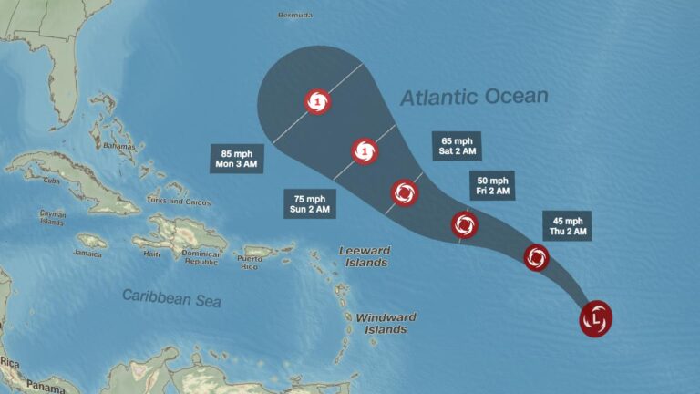
As the remnants of Hurricane Gabrielle sweep across Europe, Spain braces for notable shifts in its weather patterns today. Meteorologists warn that the lingering effects of the storm could bring increased rainfall, gusty winds, and unsettled conditions to various regions of the country. This article explores how Gabrielle’s residual impacts are expected to influence Spain’s weather, the areas likely to be most affected, and what residents can anticipate in the coming hours.
Impact of Hurricane Gabrielle Remnants on Spain’s Weather Patterns Today
As the remnants of Hurricane Gabrielle traverse the western Mediterranean, Spain is witnessing a notable shift in its weather dynamics today. The leftover moisture and energy from the storm are contributing to increased cloud cover and scattered rainfall across the southern and eastern regions, particularly affecting Andalusia and Murcia. Meteorologists emphasize that although the hurricane has weakened substantially, its residual impact is enough to destabilize the atmosphere, leading to isolated thunderstorms and gusty winds in coastal areas.
Key weather changes to watch for include:
- Intermittent showers throughout the afternoon, especially near the Mediterranean coast.
- Temperature drops of 2-4 degrees Celsius compared to the previous day.
- Enhanced wind speeds reaching up to 50 km/h in exposed zones.
- Rougher sea conditions impacting maritime activities.
| Region | Rainfall (mm) | Wind Speed (km/h) | Temp Change (°C) |
|---|---|---|---|
| Andalusia | 8-12 | 40-50 | -3 |
| Murcia | 5-9 | 35-45 | -2 |
| Valencia | 2-5 | 30-40 | -2 |
Regions Most Vulnerable to Severe Weather and What to Expect
Spain’s coastal areas, especially along the Mediterranean and parts of Andalusia, are currently on high alert due to the lingering effects of Hurricane Gabrielle. These regions are prone to intense rain showers and sudden flooding, amplified by the storm’s remnants moving across the Iberian Peninsula. Residents and visitors should prepare for heavy downpours, gusty winds up to 70 km/h, and localized flash floods, particularly in cities such as Málaga, AlmerĂa, and Cartagena. Inland provinces with poorer drainage infrastructure can also expect disruptions, as saturated soils increase the risk of landslides in hilly terrains.
Meanwhile, northern areas like Galicia and Asturias face a different threat: cooler temperatures combined with persistent winds. Weather services warn of potential travel delays due to wet roads and low visibility, with conditions expected to gradually improve by late evening. Authorities recommend keeping an eye on live updates and adhere to emergency advisories, especially in the vulnerable zones listed below:
- Andalusia Coastal Strip: Flood-prone with storm surge risks
- Murcia and Valencia: Heavy rainfall and strong gusts expected
- Inland mountain regions: Landslides and isolated road closures
- Galicia and Asturias: Persistent winds and cooler than average temperatures
| Region | Primary Risk | Expected Weather | Precaution Level |
|---|---|---|---|
| Andalusia Coast | Flooding | Heavy rain, gusts 65-70 km/h | High |
| Murcia | Flash Floods | Showers, wind 50-60 km/h | Moderate |
| Galicia | Wind damage | Windy, cooler temps | Moderate |
| Mountain interiors | Landslides | Rain, unstable terrain | |
| Mountain interiors | Landslides | Rain, unstable terrain | High |
| Valencia | Heavy Rain & Wind | Showers, gusts 55-65 km/h | Moderate |
| Asturias | Wind & Low Temps | Persistent winds, cooler | Moderate |
If you want me to help with anything else, such as summarizing risks or drafting safety advice, please let me know!
Safety Measures and Precautionary Recommendations for Residents and Travelers
Residents and travelers are urged to stay vigilant due to the unstable weather conditions caused by the remnants of hurricane Gabrielle. Strong winds and sporadic heavy rainfall can result in localized flooding and hazardous road conditions, especially in coastal and low-lying areas. It is highly recommended to avoid unnecessary travel, especially in the afternoon and evening when rain bands are expected to intensify. Keep emergency kits ready, including flashlights, batteries, and drinking water, and ensure that mobile devices are fully charged to receive real-time weather alerts and updates.
Precautionary actions to consider include:
- Avoid parking vehicles near trees or poorly secured structures
- Secure outdoor furniture and loose objects that could become projectiles
- Follow local authority instructions and do not attempt to cross flooded roads
- Keep informed via official meteorological updates and emergency broadcasts
- Plan alternate routes if traveling is unavoidable, preferably on main roads known for better drainage
| Risk Factor | Expected Impact | Recommended Action |
|---|---|---|
| Wind Gusts | Up to 70 km/h, potential power outages | Stay indoors, secure windows |
| Heavy Rain | Localized flooding in urban areas | Avoid low-lying areas, monitor flood warnings |
| Road Conditions | Slippery and flooded roads | Drive cautiously or delay travel |
The Conclusion
As the remnants of Hurricane Gabrielle continue to influence Spain’s weather today, residents across the region can expect intermittent heavy showers, gusty winds, and fluctuating temperatures. Meteorological agencies urge caution as localized flooding and travel disruptions remain possible throughout the day. Authorities will monitor the situation closely, providing updates as needed to ensure public safety. Stay tuned for further developments as the post-tropical system moves across the Iberian Peninsula.


