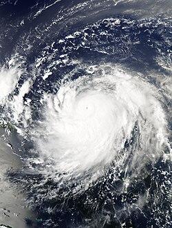
Erin has been officially designated as the first hurricane of the Atlantic season, marking an early development in what meteorologists anticipate to be an active period. Despite its upgrade to hurricane status, the storm is not expected to make a direct landfall on the United States, according to the latest forecasts. Officials continue to monitor Erin’s trajectory closely as it moves over open waters, while communities remain alert to any potential changes in its path.
Erin Emerges as First Hurricane of the Atlantic Season with Limited Threat to Mainland
Hurricane Erin has officially been designated as the first hurricane of the 2024 Atlantic season, marking an early shift in the tropical weather pattern after a relatively quiet start. Currently tracking over open waters in the central Atlantic, Erin has intensified to Category 1 status with sustained winds reaching up to 75 mph. Meteorologists emphasize that despite its strengthening, Erin poses minimal danger to the U.S. mainland as its projected course remains well east of the coastal states, drifting toward the open ocean.
Forecasters continue to monitor key factors influencing Erin’s trajectory and intensity, including sea surface temperatures and atmospheric conditions. Current models suggest the storm will gradually weaken over cooler waters, limiting any potential impacts. Key points to track regarding Hurricane Erin include:
- Maximum sustained winds: 75 mph (Category 1)
- Current location: Central Atlantic, moving northwest
- Projected path: Staying east of U.S. coastlines
- Potential impacts: Elevated seas and rip currents along parts of the eastern seaboard
| Metric | Value |
|---|---|
| Wind Speed | 75 mph |
| Pressure | 987 mb |
| Movement | NW at 12 mph |
| Category | 1 |
Meteorologists Analyze Erin’s Path and Potential Impact on Coastal Communities
As Erin churns across the Atlantic, meteorologists are closely monitoring its trajectory to provide accurate forecasts for vulnerable coastal regions. Current data suggest that while the hurricane is exhibiting increased intensity, its path is expected to veer away from a direct impact on the US mainland. However, forecasters emphasize the importance of remaining vigilant as Erin’s outer bands could still bring heavy rainfall and gusty winds to select coastal areas along the Eastern Seaboard.
Key factors guiding predictions include sea surface temperatures, prevailing wind patterns, and atmospheric pressure systems. Experts highlight the following considerations in their analysis:
- Steering Currents: The subtropical ridge is influencing Erin’s northeastward shift, lowering the likelihood of a landfall.
- Intensity Fluctuations: Slight strengthening is possible due to warm ocean waters, but rapid intensification remains unlikely.
- Coastal Effects: Even without a direct hit, communities may experience coastal erosion, high surf, and localized flooding.
| Coastal Region | Expected Impact | Preparation Level |
|---|---|---|
| Outer Banks, NC | Moderate rain, gusty winds | Advisory |
| Long Island, NY | High surf, minor flooding | Watch |
| New England Coast | Isolated showers | Informational |
Safety Measures and Preparation Tips for Residents Amid Early Hurricane Development
As early signs of cyclone Erin emerge, residents in coastal and nearby areas should prioritize proactive safety measures. Securing loose outdoor items, such as patio furniture, trash bins, and garden tools, helps prevent potential damage or injuries caused by strong winds. It is also crucial to check and replenish emergency kits with essentials like bottled water, non-perishable food, medications, flashlights, batteries, and important documents. Staying informed through reliable local authorities or NOAA updates ensures timely awareness of any changes in Erin’s path or intensity.
Preparation extends beyond supplies. Establishing a clear communication plan with family members, identifying nearby shelters, and reviewing evacuation routes remain key. Below is a quick-reference guide to critical actions residents can take now:
| Safety Step | Recommended Action |
|---|---|
| Emergency Kit | Water, food, medications, flashlight, batteries |
| Outdoor Items | Secure or bring indoors |
| Communication | Share plans & check-in points |
| Evacuation Routes | Know at least two alternatives |
| Information Sources | NOAA updates, local emergency alerts |
To Wrap It Up
As Hurricane Erin marks the official start of the Atlantic hurricane season as its first named storm, forecasters emphasize that while the system is not expected to make a direct hit on the U.S. mainland, residents along the coast should remain vigilant. Authorities continue to monitor Erin’s path closely, urging preparedness as conditions can evolve rapidly. Stay tuned to official updates from the National Hurricane Center and local weather services to ensure you have the latest information.


